
Where the Woozle wasn't
Wildlife in the Stiperstones Area
The wildlife on the Stiperstones is allegedly very diverse ranging from lizards to Skylarks, and Emperor Moths to wild ponies. Unfortunately I have to take other people's word for most of these. Wildlife watching is something that requires time, patience and silence. For me the hills are all about stomping around with an oversize rather ineffective retriever at my side. I can recognise the sound of a squirrel disappearing into the undergrowth, a grouse flapping its ridiculously stubby wings or a grumpy badger growling from under the hedge. But these are all heard and almost never seen.
During the summer months the hills are used as common grazing land by several of the local farmers. Both sheep and cows wander over the hillside cropping the whinberries, heather and grass. Whilst Highland Cattle and Shetland ponies often inhabit some of the fields adjoining the area. Under their “Back to Purple” campaign, Natural England are using Exmoor ponies and Hebridean sheep to help turn what was until recently coniferous plantation forest back into heather clad heathland.
In the late autumn the farm animals return home and the most commonly spotted animal on the Stiperstones is the escaped pheasant on the run. Born and raised in captivity these bird brained convicts have the trained reflexes of a coiled sloth coupled with the survival instincts of the dodo. They are known for hurling themselves either at passing cars, or into the jaws of unsuspecting dogs whilst making fabulous helicopter sound effects. They do however make great winter fodder for the foxes which gives the village chicken coups a welcome respite.
The one time I can vouch for animal activity is when walking in the snow. The tracks of small animals criss-cross the fields and woodland paths providing the dog owner with some insight as to their pets erratic behaviour when they manically quarter the ground unsure of which animal to chase first. In the morning the tracks of mouse, shrew, rabbit and hare can all be seen, often shadowed by the tracks of a keenly hunting fox! Unfortunately I've never found tracks for any big cat however the ones I once mistook for a werewolf ended up belonging to a friends golden retriever with ridiculously oversized feet!
At dusk the dingles are often visited by bats who nest in the abandoned mine shafts which pepper this area, and through the moonlit nights the werewolves which live in the hedgerows between the Stiperstones Inn and the Blackhole keep travellers company as they wend their way home (well what else could be making all those strange noises?). For more information please visit the Natural England and Shropshire Wildlife Trust websites.
Food for Free!
The Shropshire hills produce a plentiful crop of wild berries every year. The best known is the whinberry. Growing wild across the Stiperstones these small purple berries have long been a key factor in the local economy. The berries taste great fresh and if you manage to bring any home with you they are wonderful in pies and crumbles and we also use them to make jams, coulis, ice-cream etc. The Whinberry crop ripens in July and is plentiful throughout August, the berries are quiet hardy however and it is common to find a few late berries through to the end of December.
The second crop on the Stiperstones hills are mountain cranberries or Lingonberries. These hard red berries ripen in November and whilst they are far less abundant than the Whinberry they can be gathered to make rich sauces.
Additional wild fruits growing along the paths include Alpine Strawberries, sweet Wild Raspberries and succulent Blackberries. Sloe Berries grow in many of the old overgrown hedgerows and a few Damson trees still remain in some of the older gardens attached to the tumbledown cottages dotted around the old mine sites.
According to many sources the ripe Rowan Berries which grow all over the lower slopes of the hills are edible, but I've tried several times with different recipes and all I can say is that they don't kill you and apart from a slight gag reflex they don't even seem to have any harmful side-effects. On the subject of side effects, there are many mushrooms growing over the hill but you'll need a much more thorough guide to these if you wish to forage for fungi.
In the later months there are crab apple trees on the lower slopes of the dingles which can have good crops, and if you get lucky you might even manage to gather a few hazelnuts before the squirrels hide them all. With all of this free food available on your walk, it is important to remember that the sheep and cattle are off limits, even if you could squeeze one into your backpack!
-
Walk 1 - I can see my house from here!
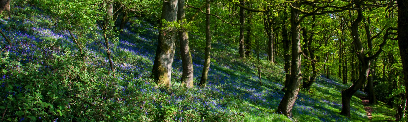
- This is one of my favourite walks, partly because it involves a limited amount of climbing, but also because it's very flexible with many opportunities to take a short-cut home if I'm short of time. I've called it a berry picking walk as there are a lot of hedgerows on the way with plenty of opportunities for picking in the late summer, but this walk is a nice easy route for most of the year. A small section of the walk from Mytton dingle to Perkin's Beach dingle can get quite prickly with gorse over-running the little path. I've listed a small detour for walkers in shorts or with small dogs who can't manage the gorse path.
This walk starts on the road, from the pub turn right and head down the road in the direction of Snailbeach. Stay on the road for about ¾ of a mile till you get to a 5-bar gate on the right hand side with a stile on the left hand side of the gate. Through the gate follow the track up the hill to another gate with a cattle grid across it. There is a small gate on the right hand side for dogs like Bob who have been unable to learn how to navigate cattle grids. Once through the gate the path heads up and to the left and then turns sharp right and through another small gate. The path now goes through the front garden of a little cottage and then going through one more gate takes you into the wood. This lovely little wood path follows the fence-line heading back towards the Stiperstones village and needs very little guidance, after about quarter of a mile you will pass an old bath set in the top of a field on your right hand side. Continue on past the bath for further quarter of a mile and you will come to a rocky outcropping which you'll need to scramble down. The path now swings round to the left and continues to follow the fence-line round to the right and then down to a second rocky scramble to the unadopted road. If you want to cut the walk short you can turn right here and head down Mytton Dingle back to the Stiperstones Inn, If not then turn left and follow this road past 2 cottages and through a wooded area until the road ends in a clearing.
Here you will find a small map of the Stiperstones and a plaque commemorating the death of all 5 crew members of a Whitley Bomber which crashed into the hillside on a training run in 1944. Just after the plaque you need to bear right and follow the small path into the woods. The path forks as you enter the wood the left hand path heading uphill is the easiest path to take, it quickly levels out and follows the contour of the hill through the wood till it reaches a fence-line (if you've taken the bottom path you'll come to a stile, don't go over the stile instead head up hill until you reach the top of the field and turn right.). Carry on with the fence on your right, twice the fence drops away on your right and both times you should take the path that leads slightly downhill to continue following the fence. (If you stay on the higher paths you're likely to get bogged down in fern and gorse). You'll pass a small summer gazebo/platform on your right and soon after this the fence-line drops again. This time continue straight on the path which winds through the ferns and the heather. You'll come to another small rocky scramble and the path once again meets up with the fence only to lose it again a few minutes later. Carry on across the next clearing till you join the fence again, follow this fence-line for a short while and then drop down to the track when it clears. Go through the 5-bar gate on your right. Once again you can choose to cut the walk short here by carrying straight on down the unadopted road in front of you (Perkin's Beach Dingle). Alternatively take the path to the left to continue the walk.
The track goes through a clearing called “New Venture” or “Ventnor” there are some small cottages on the left and mine working scattered throughout the hills above. Follow the track round and you'll come to a small white cottage, here the track becomes a path up to your left where it meets a stile (with dog stile). Head over the stile and up the hill keeping right till you come to a small stream. 90% of the time you can hop across the stream to the path on the other side. If it's a bit boggy follow the stream uphill till you find an easier crossing point. The path follows the fence-line up the hill and round to the right stay on the path and you'll come to another small stream (sometimes just a boggy patch, which can be a bit smelly – dog owners beware!) which is the run off from one of the old mine workings. The path continues straight for a short while and then heads down through the woods. Just before the main path levels out at the bottom there is a small path on the right hand side. Here you have a choice – the lower path is wider and easier, but it drops down and then climbs back up again. The higher path is a bit more of a scrambly sheep-path, but it stays at the same level. The paths join back up again after about half a mile at the top of a sheep field with a stile. Don't go over the stile. Follow the path along the line of the fence where you'll find another stile (and dog stile) leading into the woods. Follow this wooded path and it will widen out into a track, keep heading straight till you come to a 5 bar gate with a stile. The gate doesn't open and the stile is slippy so be careful over this one. There also isn't a dog stile here, but as there's no fence either it's easy for the dogs to head round through the undergrowth on the outside.
This is your final chance to head back home early. Just follow the road to the right back down to the pub. Alternatively turn left and head up the road for about 100 yards. You'll come to a wide sweeping bend which has great views across the valley. If you stand on the corner looking down the valley with the unadopted road on your left, you can have a quick check for cows in the fields infront and to your left. If there are cows in the field and you have a dog with you then I heartily recommend cutting the walk slightly short and heading back down the road as these particular cows tend to be on the grumpy side. If the field is clear then head down the unadopted road till you come to a 5-bar gate on your right. Through the gate (it can be very muddy on the left hand side so be careful) and follow the tractor trail slightly up hill. The path now heads slightly right across the field to meet up with the fence-line of the woods. At this point the official path on the map appears to be inside the wood itself, but there is no way into the wood here, a track does follow between the fence and the brambly hedgerow, but this path is often very boggy so it may be easier to walk in the field with the brambles on your left until you reach the end of the field. Head through the gate into Buxton wood. The path wanders through the wood for a while until it forks, take the left hand fork up the hill to the top and then continue on dropping down slightly till you get to another 5-bar gate. Heading through the gate you're still in woodland but this part is also farmland and often has sheep. Follow the track down through the wood and continues on till you come to two more 5-bar gates which are set close together. Head through them both and you'll be on another unadopted road. Follow the road down and it'll lead you back to the main road. When you join the main road head right and the Stiperstones Inn is just round the corner.
I hope you've enjoyed this walk as much as I do.
A map for this walk can be found here on the Walk for Life site. -
Walk 2 - Climb Every Mountain, Ford Every Stream
- Ok so it's really a hill and there's only one stream but I like catchy titles.
Starting from the phonebox follow the left hand road (Mytton Dingle) as far as the five bar gate. Once through the gate turn left and climb up the path following the fence line – there's a little scramble over rocks at first but there is a path there honest. When the path starts to level out look for a smaller path heading up to the right (the path is generally marked by tyre tracks as the mountain bikers like to come down this route). Again there is a little bit of a rocky scramble here but you soon get on to the ridgeline path which wends its way up the hill. I think there are at least 7 false summits on this climb and counting them helps to distract me, alternatively take time to admire the view every 50 yards or so, on a clear day you can see Rodney's Pillar and you get a great view of Corndon Hill and the Callow (a small domed hill with a crown of trees).
When you reach the top of the hill the path drops slightly and joins a Landrover track. Follow the track to the left and then take the footpath to the right which heads down the dingle. This path follows along the side of a small stream for a while and you are expected to ford it at least twice. When you get to a fenced field the path continues alongside the with the field on your right hand side down to a stile (with dog stile). Once across the stile you will see a small cottage on the right hand side. Without electricity or water this old miner's home has been frozen in time and is lovingly maintained by the former residents' granddaughter.
Follow the track past the cottage and through a five bar gate. Once through the gate take the wide path on the right hand side which heads back up the hill you've just come down. (personally I find this a pointless exercise but people seem to enjoy the “because its there” style of climbing). This short steep climb takes you quickly back to the top at which point you should turn right and follow along the side of fields until you pass the large tree on your right. After the tree the path bears right across the field where there is a wicket gate leading back onto the heather-clad hill. Continue along this path until you meet up with the wider track.
Turn right on the track and follow it as it wanders off to the left and uphill once again. When you reach the top you need to look out for another Landrover track heading off to the right. This track is rarely used and the heather has grown up in the centre partially hiding the treads. (If you reach a crossroads with a cairn of stones in it you have come too far, but don't worry just take the path on the right which leads downhill back to Mytton Dingle and ultimatly to the phonebox). Assuming you have found the track it will take you down to an open gravelled area. This is the top of the flooded wires, created when a shallow mine flooded during heavy rain storms and collapsed.
As a child (and more than once as an adult) I rolled down the hill from here. Rolling through the heather is however not a comfortable experience and has many health and safety issues so I obviously couldn't recommend it as a way down. Alternatively turn, so your back is facing the flooded wires and head down the nice wide open green slope instead. (don't roll down this as it is full of sheep droppings) Keep to the left side of the field, the slope will join up with an old green road and you will see some ruined remains of buildings on your left. When you get to the small pool on the left, turn right and head down the hill. From here it's downhill all the way.
At the bottom of the green field there is a solitary tree with two very low branches, these are perfect for a little sit down if you feel like a rest. When you're ready continue down the hill. Stay on the path and you will come to a five bar gate, once through here you are onto an unadopted road (Perkins Beach Dingle) which heads down to the phonebox by the Inn. Congratulations assuming you didn't get lost along the way you have completed xxx mile walk with xxx metres of climbing, I think you deserve a drink, but then again I would wouldn't I!
A map for this walk can be found here on the Walk for Life site. -
Walk 3 - Dash & Dawdle
- A Stiperstones Christmas tradition. This is the shortest of my walks – but definitely not the easiest.
Every Boxing Day hundreds of people walk or run up to the Devil's Chair and back, raising money for charity and helping themselves to recover from Christmas excesses. The record time for the Dash is just over 20 minutes but most people just try to get there and back again within an hour. On Boxing Day morning a group of volunteers sit on the chair waiting to mark the race cards and pass out drinks to those who aren't too busy trying to get back down, but I'm afraid for the rest of the year you'll need to take your own refreshments.
The race leaves from the phone box by the Inn. Taking the right hand lane (Perkins Beach Dingle) follow the road for almost a mile until you reach a five bar gate. Go through the gate and continue on up the path. After you have passed the grey mound you will come to a tree at the bottom of a steep green field. - This tree is a perfect spot for having a quick sit and looking back at the view.
At the top of the green field there is a small pool. You need to pass on the right of the pool going under the branches of the tree. After this there is another climb up a green field heading slightly right until you rejoin the path. Continue on up the path until you reach a small cairn of rocks (this is marked on the OS map as a bronze age cairn). Turn right at the crossroads and head towards the large rock outcroppings. Go straight over at the next crossroads and continue towards the ridge. The path gets very rocky at this point so you'll need to tread carefully. If you feel the need to look at the view it's better to take a moment to look around rather than risking a turned ankle by admiring the view whilst walking.
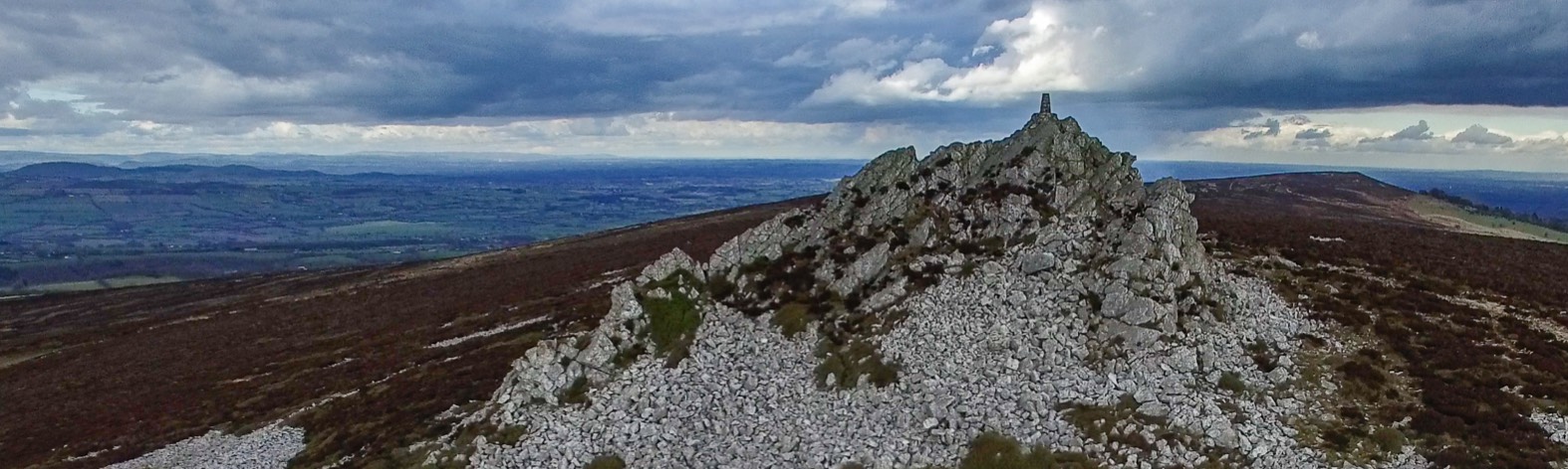
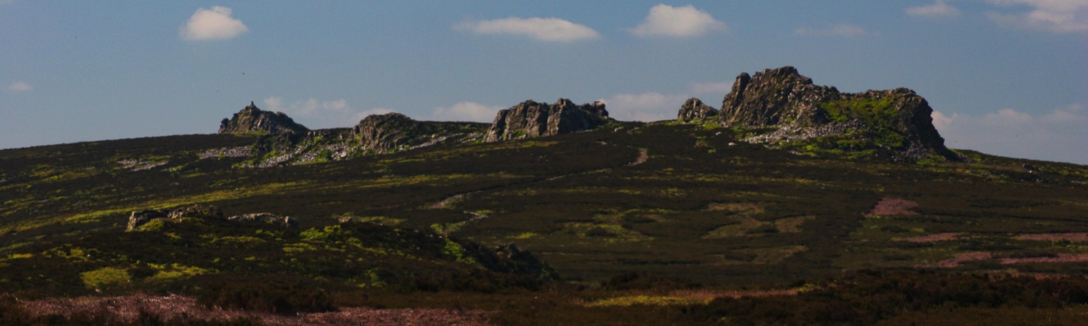
The Devil's Chair is the first large rock outcropping you come to. Unfortunately unless you're there on Boxing Day morning you won't find a friendly Santa ready with a nip of something warming. You will however have the knowledge that the way home is all downhill and a warm welcome awaits you at the Inn at the bottom after you have retraced your steps. Sproson.com has more details on the Dash and Dawdle.
A map for this walk can be found here on the Walk for Life site.